
The Live Tracking screen empowers users to effectively oversee the activities and movements of vehicles or assets in real time. It provides an interactive and dynamic view, constantly updating with the latest data on the movement, location, status update, and other associated features of the objects.
Watch : Object List Overview.
Watch : Map & Object Tooltip Overview
Key Highlights:
- Real-Time Monitoring: Stay updated on the current status and movements of vehicles or assets as they happen.
- Dynamic Interface: An intuitive and interactive layout makes it easy to visualize and track objects on the map.
- Real-Time Notification: Get instant alerts about vehicle activities like driving violations, ignition changes, geofence crossings, maintenance reminders, and more.
- Customizable Features: Change the tooltip to display the information according to your needs.
- Enhanced Visibility and Control: Access to live data empowers users to make informed decisions, ensuring smoother and more efficient fleet management.
The Live Tracking screen is an essential component for maintaining operational efficiency and optimizing fleet performance.
Users can review daily activities, including jobs, alerts, vehicle playback history, and other events that occurred during the day.
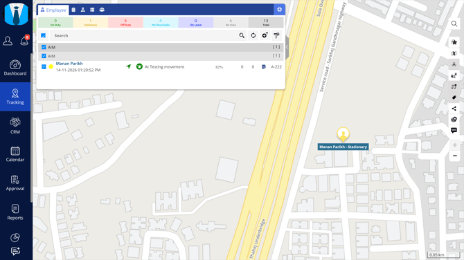
To open the live tracking screen, click on Menu > Tracking > Live Tracking in the application, as highlighted in the below-given image.
Listing Panel
On the left side of the screen, you will find the listing panel, which provides a comprehensive overview of various listings as described below:
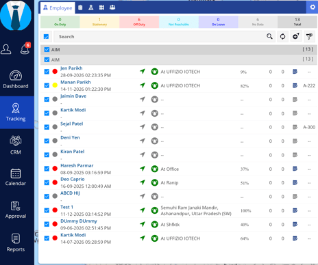
Employee Tab
The Employee tab displays a summary of employee statuses, including On Duty, Stationary, Off Duty, Not Reachable, On Leave, and No Data, providing a centralized view of employee availability and activity.
Task Tab
The Task tab displays a summary of tasks based on their current status, including Completed, Upcoming, In Progress, and Missed, allowing users to monitor and track task progress.
Address Tab
The Address tab displays a list of created addresses with their associated details, allowing users to view and manage addresses for efficient monitoring.
Area / Geofence Tab
The Area / Geofence tab displays the created areas and geofences with their details, allowing users to view and manage geographical boundaries for monitoring and tracking purposes.
Contact Name Tab
The Contact Name tab displays contact information associated with different geographical locations, allowing users to view and identify contacts based on their geographic location.
Map Tools
On the right side of the screen, we have Map tools, as shown in the image below:
Map tools are as listed below:
 |
Search Users can conveniently search for any screen using this option, eliminating the need to navigate through different menus. |
 |
Favourite Users can easily access the reports they have marked as favorites through this option. |
 |
Select Map We provide OSM Map, but if the users have purchased any Map Keys then they can select other maps from here accordingly. Check how to configure Map. |
 |
Use/Remove Cluster The cluster option is used to view the number of vehicles in a particular area on the map. |
 |
Traffic Monitor real-time traffic conditions on the map using this feature. |
 |
Object with Path By clicking on Object with Path, the user can view the route taken by the object on that day. |
 |
Show Label The user can click on Show Label to view the objects with their labels. |
 |
Share Live Location Click on this icon to share the live location of multiple objects at a time. |
 |
Users have the ability to explore nearby vehicles, addresses, or points of interest (POI) in relation to a specific location using this feature. |
 |
Single Object Mode The user can view only the selected object on the map by clicking on Single Object Mode. |
 |
Journey Route The Journey Route tab allows users to view employees' travel routes on the map, providing a visual representation of the routes travelled during their journeys. |
 |
SOS The SOS tab displays emergency alerts triggered by employees, allowing users to monitor distress signals, view the employee's location, and respond promptly to emergency situations. |
 |
Zoom In User can zoom in on the map using Zoom In. |
 |
Zoom Out User can zoom out on the map using Zoom Out. |